Student project on counting people on the beach

For the course 3D surveying of civil and offshore infrastructure at TU Delft a group of students has worked on counting the people that are walking on the beach using our CoastScan data from Noordwijk. In their final report they present their method that is able to detect up to 90% of the people that are walking on the beach in an area of about 400 m length in front of the laser scanner.

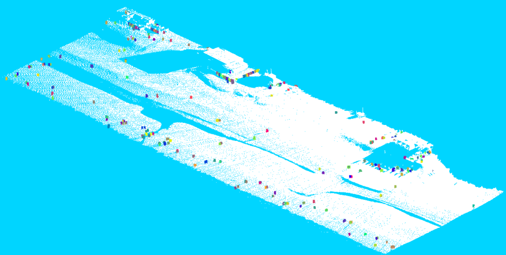
Point cloud of the beach in Noordwijk with people detected by the algorithm marked in colors.

Master Project deals with visualizations of CoastScan data

In February 2021 Y. Schreijer successfully completed her master thesis with the title: ‘Visual insight into the temporal changes of sand patterns along the Dutch coast’ under the supervision of E. Verbree and P. van Oosterom (TU Delft) and P. Goessen (Hoogheemraadschap Hollands Noorderkwartier). For her master project she used CoastScan data to visualize dynamics that influence deformation processes of the coast.

The image shows elevation differences in Noordwijk after a storm hit the coast in early February 2020. A large sand deposition is circled in red.

In a comparison between two consecutive scans (about one hour apart) moving sand ripples, possibly caused by aeolian sand transport due to strong winds, are made visible.